


Col de Tende

jfdeligementon
User
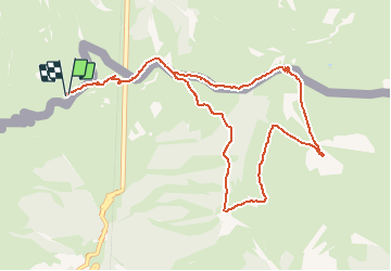

Length
11.4 km

Max alt
2289 m

Uphill gradient
522 m
Km-Effort
18.4 km

Min alt
1864 m

Downhill gradient
522 m
Boucle
Yes
Creation date :
2021-03-04 20:30:34.826
Updated on :
2021-03-04 20:30:55.116
4h10
Difficulty : Difficult

FREE GPS app for hiking
 SityTrail
IGN / Geographical institutes
SityTrail Plus
The world is yours!
About
Trail Walking of 11.4 km to be discovered at Piemont, Cuneo, Limone Piemonte. This trail is proposed by jfdeligementon.
Positioning
Country:
Italy
Region :
Piemont
Department/Province :
Cuneo
Municipality :
Limone Piemonte
Location:
Unknown
Start:(Dec)
Start:(UTM)
384995 ; 4889515 (32T) N.
Comments